03-6272-4372営業時間 9:00〜18:00
防災メディア
Sharing information with GIS
2017/07/04
This image shows the kinds of organizations that want to share their geospatial information better and to use that information in the most effective ways possible when they make decisions during a disaster or when planning for emergency responses and recovery later. In the beginning of GIS (Geographic Information System) the computers were big and slow, and data was time-consuming to collect and add to the database. Even now with small, fast machines and easy data importing and exporting still the main use for GIS continues to be local property records and city planning. But seeing a location with visual data displayed geospatially is a good way to make decisions, to analyze past situations, and to imagine possible future directions to develop in wide areas like neighborhoods, metropolitan areas or entire ecosystems.
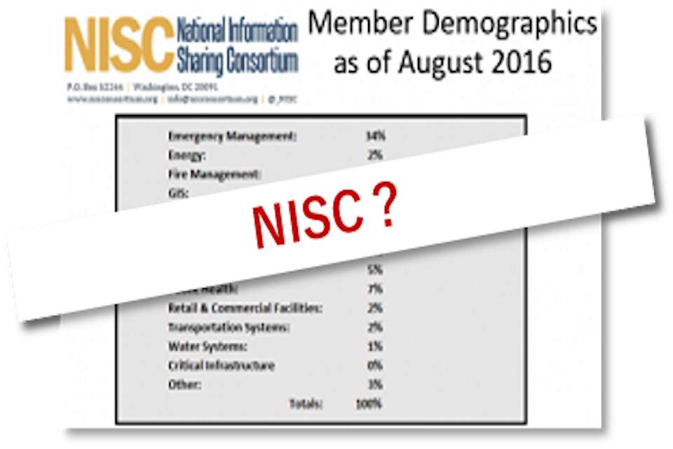
So it is not surprising that emergency planners and disaster managers want to collect, use and share GIS data with others who are involved in a particular event now occurring or for a future risk that is being planned for. Starting in 2012 the first organizations came together to form the NISC (National Information Sharing Consortium). This 26 minute movie about the NISC by current director, Mr. Sean McSpaden, gives a good, visual introduction to the project. Major financial support comes from DHS (Department of Homeland Security in USA including FEMA, the Federal Emergency Management Agency), as well as corporate contributors, the very biggest being ESRI (a GIS company) and G & H International (also deeply involved in GIS work). As the NISC name says, the goal is to share information so that everybody, around USA and abroad, can wisely use all the GIS techniques to answer the questions needed to make good decisions and to coordinate emergency response based on a Common Operating Picture (C.O.P.). The NISC website has several parts, some of which is public and some of which requires (free) membership or request to view. There are online webinars recorded from members’ presentations about various GIS uses and experiences. There are software widgets to download and use for filtering GIS data and displaying only the information needed in the emergency situation. There are demonstrations of GIS-related services and problem solving (for example, the Virtual USA project for drawing multiple live data sources onto one’s own location).
It is easy to imagine that the NISC keeps live data about all world locations, but it is not a global Emergency Operation Center. The purpose of the consortium is to benefit its members by sharing new technology, lessons learned when using GIS in order to understand a disaster location and the surrounding emergency crews; to promote better use of geospatial information sharing –uploaded computer language code, single-purposed dedicated software widgets to filter the GIS data; and to host webinars for members or guest presenters to educate the rest of the consortium members. When the NISC participated in the planning and the exercise of Capstone-14 in June of 2014 with the Central U.S. Earthquake Consortium it was possible to test many ideas and tools in a full-scale exercise. This was a very big process that brought the GIS way of thinking to many of the organizations who got involved in the week-long events in the eight states touched directly by the New Madrid earthquake that is expected to cause great damage and suffering sometime in this generation or the next. The dream of the NISC is one day for disaster response to have an accurate, understandable, and timely shared picture of events as they occur; or as they say: to give “the right person the right information at the right time.”